With southern Arizona hitting a constant high of 107°+ the past couple weeks, we needed a quick escape to cool down so we headed to what we consider our favorite place in the state, the White Mountains.
…and we arrived at the same time monsoon season did. We were hit with rain on the drive through Show Low and Pinetop-Lakeside but by the time we got to the East Baldy Trailhead, the rain clouds had moved on so we hit the trail!

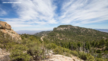
East Baldy Trail #95 is a moderate 14-mile total out and back hike that follows near the Little Colorado River. It connects with West Baldy Trail #94 and the Mount Baldy Crossover Trail #96 to create a loop (the loop is 16.5 miles total). The actual summit of Mount Baldy is half a mile away but is part of the White Mountain Apache Indian Reservation and is closed to all non-tribal members as it is considered one of the most sacred mountains. Permits can be applied to from the White Mountain Apache Tribe Game & Fish Department.
The clear-cut trail through meadows and forests mixed with white pine, Douglas fir, aspen, and ponderosa trees reminded us of our adventures in Colorado. The wildflowers in bloom in all sections of the trail were an added bonus to the beauty of the area.
I was in wildflower heaven and may have taken more than a dozen photos of all the blooms found along the trail!
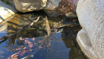
Phelps Spring
Can you spot the mule deer?
This horsefly was enjoying the wildflowers as much as I was.
Husband wondering what such tall trees were doing in Arizona!
As the trail climbs, it winds up through a maze of sandstone boulders and mixed conifer.
Thunder rumbled in the distance as we were hiking through the trail and began to sound louder and closer as time progressed. By the time we headed back, the clouds started to pour again so we pulled out our rain jackets. The trees provided some coverage and by the time we were out in open meadow, the rain had moved on.
We were exhausted by the time we finished our hike but what a beautiful place to be exhausted in!
| East Baldy Trail Overview | ||
|
Coordinates / Address 33.930775, -109.4913472 |
Fees / Permit FREE / None |
Difficulty Moderate |
|
Usage Light |
Pets allowed Yes |
Camera Info Canon 6D + 24-70mm f/2.8L II |
Length 14 miles out and back |
Elevation Gain 2,296 |
Tips & Things to Note Bring bear mace |